Underground Utility Locating Guide: 811, GPR, Electromagnetic Locators, Potholing, and SUE Levels | Projul
Why Utility Locating Matters More Than You Think
Every year in the United States, excavation crews hit buried utilities roughly 800,000 times. That is more than 2,000 strikes per day. These incidents cause injuries, fatalities, environmental damage, service outages, project delays, and enormous liability exposure. A single gas line strike can level a building. A severed fiber optic cable can knock out communications for an entire city block.
The frustrating part is that nearly all utility strikes are preventable. The technology exists to find buried utilities before you dig. The laws require it. And the process, while not always fast or cheap, is straightforward. Yet contractors keep hitting lines because they skip steps, rely on incomplete information, or assume that the 811 locate marks are precise enough for their work.
This guide covers the full range of underground utility locating methods, from the free 811 service to advanced SUE (Subsurface Utility Engineering) investigations. Whether you are digging footings, trenching for new utilities, or grading a site, understanding these tools and processes keeps your crew safe, your project on schedule, and your company out of court.
The 811 System: Your Legal Starting Point
Before you put a bucket, blade, or shovel in the ground, you are required by law to contact 811 (or your state’s one-call center). This applies in all 50 states, though the specific rules vary by state.
How 811 Works
- You call 811 or submit a request online (most states now have web-based ticket systems). Provide the dig location, type of work, planned excavation depth, and start date.
- The one-call center notifies all member utilities that have infrastructure in the area: gas, electric, telecom, water, sewer, cable, fiber, etc.
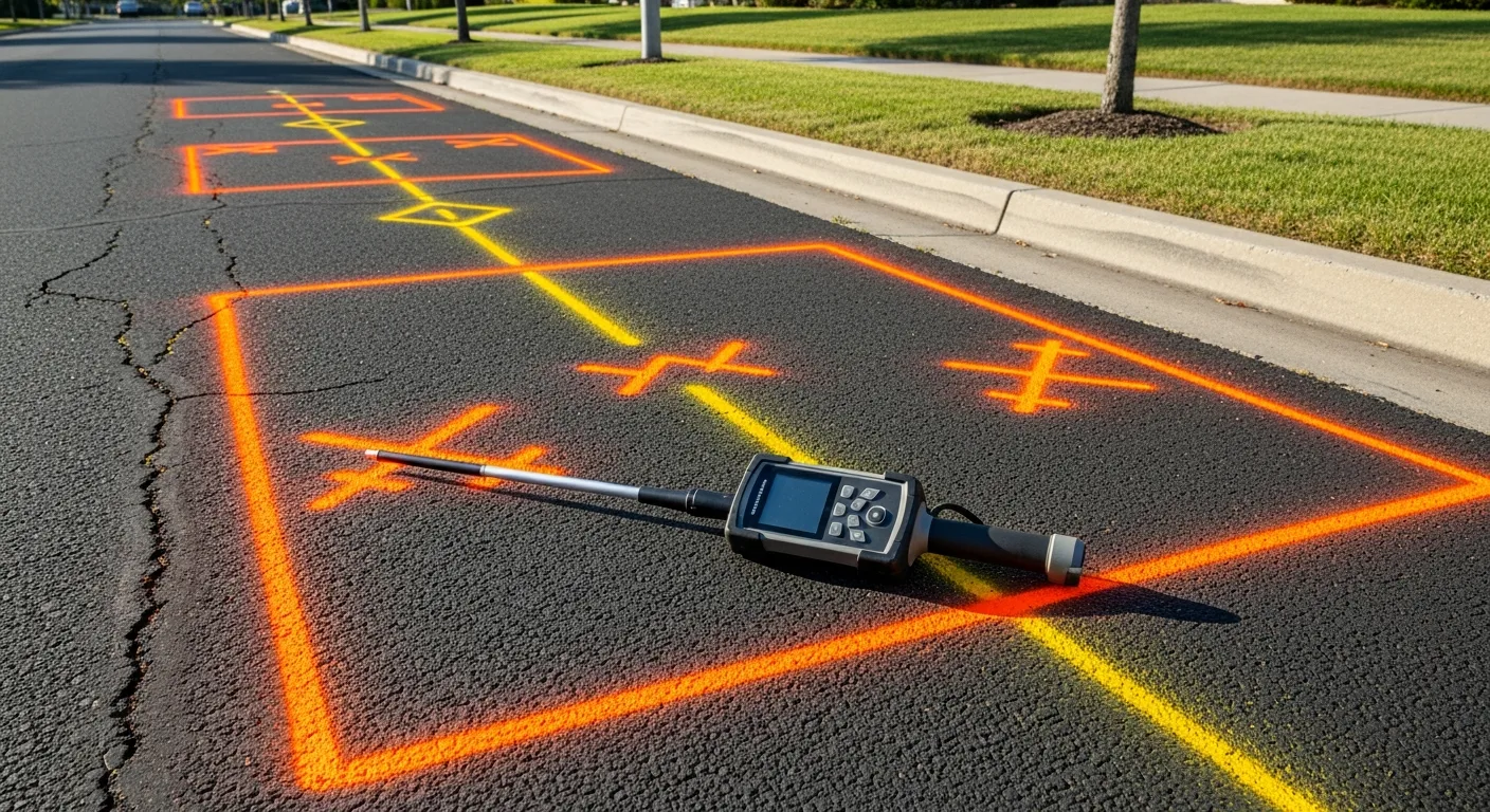
- Each utility sends a locator to mark the approximate location of their lines using standardized color-coded paint and flags.
- You wait the required time (typically 2 to 3 business days, though some states allow shorter windows for emergencies).
- You verify the marks are present for every utility that was notified. If a utility has not responded, do not dig in their area until they do.
- You hand-dig or use non-destructive methods within the tolerance zone (typically 18 to 24 inches on each side of the marks).
Color Codes for Utility Marking
The APWA (American Public Works Association) uniform color code is used nationwide:
- Red: Electric power lines, cables, and conduit
- Yellow: Gas, oil, steam, petroleum, and other hazardous materials
- Orange: Telecommunications, alarm, signal, and cable TV
- Blue: Potable water
- Green: Sewer and storm drain
- Purple: Reclaimed water, irrigation, and slurry
- Pink: Temporary survey markings
- White: Proposed excavation area (you mark this before calling 811)
What 811 Does Not Cover
This is where contractors get into trouble. The 811 system has significant gaps:
- Private utilities: Lines on private property that run from the meter or connection point to the building are usually not in the 811 system. The property owner is responsible for these, but they are rarely marked.
- Abandoned utilities: Old, decommissioned lines may still be in the ground but are not in anyone’s records.
- Accuracy limitations: 811 locates are approximate. The tolerance zone (18 to 24 inches) means the actual utility could be up to 2 feet from where the paint line is.
- Depth information: 811 marks show horizontal location only. They do not tell you how deep the utility is buried.
- Incomplete records: Utilities that were installed before modern record-keeping (pre-1970s in many areas) may not appear in anyone’s database.
Electromagnetic (EM) Locating
Electromagnetic locators are the primary tool used by both 811 locators and private utility locating companies. They work by detecting the electromagnetic field generated by or induced onto a metallic conductor underground.
How EM Locating Works
There are two modes of operation:
Passive mode: The locator detects electromagnetic fields that are already present on a buried conductor. Energized power lines and cables carrying current generate their own fields. Some metallic pipes and conduits also pick up stray electromagnetic energy from nearby sources. Passive mode is a quick initial sweep to identify live utilities.
Active mode: The operator connects a transmitter to a known utility (by direct connection, induction clamp, or broadcast induction) and sends a specific frequency signal along the conductor. The receiver then traces this signal along the utility’s path, identifying its horizontal location and estimating its depth.
Active mode is far more accurate than passive mode because you are tracking a known signal on a known utility rather than interpreting ambient fields.
Strengths of EM Locating
- Works well on metallic pipes and cables (steel, copper, aluminum, ductile iron)
- Can estimate depth (most receivers calculate depth from signal strength)
- Relatively fast for tracing long runs of known utilities
- Equipment is portable and relatively affordable ($2,000 to $15,000 for professional units)
- Industry-standard method with decades of proven use
Limitations of EM Locating
- Cannot detect non-metallic utilities. Plastic (PVC, HDPE) water lines, plastic gas lines, clay sewer pipes, concrete storm drains, and fiber optic conduit without a metallic tracer wire are invisible to EM locators.
- Signal bleed. The electromagnetic signal can jump from one metallic conductor to another where they are close together, causing the locator to follow the wrong utility.
- Congested areas. In urban environments with dense utility networks, separating individual signals is extremely difficult.
- Depth accuracy. Depth estimates from EM locators are approximate, typically plus or minus 15% to 20% of the actual depth.
Tracer Wire
To make non-metallic utilities detectable by EM locators, a metallic tracer wire (or locating wire) is installed alongside the pipe during construction. This is now standard practice for new plastic utility installations, but millions of miles of older plastic utilities were installed without tracer wire and remain undetectable by EM methods.
Ground Penetrating Radar (GPR)
GPR fills the gap that EM locators cannot cover. It detects buried objects based on density differences in the subsurface, regardless of whether the object is metallic.
How GPR Works
A GPR unit consists of a transmitting antenna and a receiving antenna, typically housed in a cart or handheld unit that the operator pushes or drags across the ground surface. The transmitter sends short pulses of electromagnetic energy (radio waves) into the ground. When these pulses hit an object or boundary with a different density (a pipe, a cable, a rock, a void, a soil layer change), some energy reflects back to the surface. The receiver records these reflections, and software processes them into a cross-sectional image of the subsurface.
An experienced GPR operator reads these images (called radargrams) to identify utilities, estimate depth, and distinguish between different types of buried objects.
Strengths of GPR
- Detects both metallic and non-metallic objects
- Shows relative depth of buried objects
- Identifies non-utility features: voids, old foundations, tanks, boulders
- Non-destructive and non-invasive
- Can survey large areas relatively quickly
- Works on paved surfaces (parking lots, roads, building slabs)
Limitations of GPR
- Soil dependent. GPR works best in dry, sandy, or granular soils. Wet clay soils absorb radar energy and severely limit penetration depth.
- Interpretation required. GPR data requires an experienced operator to interpret. The radargram is not a photograph; it is a representation of reflected energy that takes training to read correctly.
- Cannot identify utility type. GPR shows that something is buried at a specific location and depth, but it cannot tell you whether it is a gas line, a water line, or an old tree root without additional information.
- Congested subsurface. In areas with many buried objects, the overlapping reflections make individual identification difficult.
- Cost. Professional GPR units cost $15,000 to $50,000+, and skilled operators command premium rates.
When to Use GPR
GPR is most valuable in these situations:
- Locating non-metallic utilities (plastic pipes, concrete structures)
- Confirming utility locations in complex or congested underground environments
- Pre-construction surveys on sites with unknown buried infrastructure
- Finding abandoned utilities, old foundations, underground storage tanks, and voids
- Working in areas where 811 information is known to be incomplete or unreliable
Potholing (Daylighting)
No matter how good your locating technology is, the only way to confirm the exact position of a buried utility is to expose it physically. This process is called potholing or daylighting.
What Potholing Involves
Potholing means excavating a small test hole directly over a suspected utility location to visually confirm the utility’s horizontal position, depth, size, material, and condition. The hole is typically 12 to 24 inches in diameter and just deep enough to expose the top of the utility.
Vacuum Excavation
The preferred potholing method is vacuum excavation, which uses high-pressure air or water to loosen the soil and a powerful vacuum to remove it. This process is non-destructive to buried utilities because air and water will not cut through a pipe or cable the way a backhoe bucket will.
Air vacuum excavation uses compressed air to break up the soil. It is gentler on utilities and works well in most soil types. The excavated soil is dry and can be used as backfill.
Hydro vacuum excavation uses pressurized water to cut the soil. It is faster than air in hard or compacted soils but creates slurry that must be disposed of. The water can also damage some utility types (insulation on district heating pipes, for example) in rare cases.
When Potholing Is Required
- Before excavating within the tolerance zone of a marked utility
- When SUE Level A accuracy is required (engineering design projects)
- Before horizontal directional drilling (HDD) crosses or parallels existing utilities
- When existing records conflict with field locates
- Before any excavation near critical high-pressure gas lines, high-voltage electric, or fiber optic trunk lines
Cost
Potholing typically costs $500 to $2,000 per hole, depending on depth, soil conditions, surface restoration requirements, and access. On a large project with dozens of potholes, costs add up quickly, but they are a fraction of what a utility strike costs.
SUE Quality Levels
Subsurface Utility Engineering (SUE) is a formal engineering discipline that applies progressively more rigorous methods to identify and map underground utilities. The American Society of Civil Engineers (ASCE) standard 38-02 defines four quality levels.
Level D: Records Research
The lowest level of investigation. The SUE engineer collects existing utility records from utility companies, municipal databases, as-built drawings, historical maps, and other documentation. This information is compiled onto the project base map.
Accuracy: Highly variable. Records may be decades old, inaccurate, incomplete, or missing entirely.
Cost: Lowest. Primarily research time.
Use: Initial project planning, early-stage design, establishing a baseline understanding of the utility environment.
Level C: Surface Features
Level C adds a field survey of visible surface features related to underground utilities: manholes, valve boxes, meters, pedestals, vent pipes, and other above-ground indicators. These features are surveyed and added to the project map.
Accuracy: Better than Level D. Provides physical reference points that correlate to underground infrastructure.
Cost: Moderate. Field survey time plus research.
Use: Preliminary design, identifying potential conflict zones before detailed design begins.
Level B: Geophysical Investigation
Level B applies geophysical methods, primarily EM locating and GPR, to designate (mark) the approximate horizontal location of utilities. The results are surveyed and added to the project map.
This is where most utility locating projects spend the majority of their budget. Level B gives you a reasonably accurate picture of what is underground and where it is, but it does not confirm depth or precise position.
Accuracy: Typically within 12 to 18 inches horizontally. Depth estimates are approximate.
Cost: Significant. Professional locators with EM and GPR equipment, plus survey.
Use: Design-phase utility coordination, identifying conflicts between proposed construction and existing utilities, planning pothole locations.
Level A: Potholing (Test Holes)
Level A is the highest quality level. It confirms the exact horizontal and vertical position, size, material, and condition of a utility through physical exposure (potholing). The exposed utility is surveyed with precision instruments, and the data is added to the project map.
Accuracy: Precise. You are looking at the actual utility.
Cost: Highest per point, but targeted. You only pothole at specific locations where exact information is needed (utility crossings, conflict points, design-critical areas).
Use: Final design, avoiding utility relocations, confirming depths at crossing points, eliminating risk at critical excavation locations.
How the Levels Work Together
A well-managed SUE investigation starts at Level D and works up to Level A where needed:
- Level D research establishes the baseline.
- Level C field survey adds surface evidence.
- Level B geophysical investigation fills in the underground picture.
- Level A potholing confirms exact positions at critical points.
Not every point on the project needs Level A accuracy. The engineer and designer identify where utility conflicts are likely and where exact data is essential, then target Level A investigations to those locations. Everywhere else, Level B data is sufficient.
Managing Utility Locating on Your Projects
Utility locating is a coordination-heavy process. You are dealing with 811 tickets, private locating companies, utility owners, SUE engineers, vacuum excavation crews, and your own excavation team. Timing matters: your 811 ticket has an expiration date, your private locator needs access before excavation starts, and your potholing crew needs to work before the trenching crew arrives.
Projul helps contractors manage this sequencing by scheduling each locating phase as a distinct task tied to your excavation schedule. When the 811 ticket is called in, log it. When the locator marks the site, document it with photos. When potholing is complete, record the depths and conditions. Everything stays in one place, attached to the project, accessible to your field crews.
If you are running multiple site-work projects with different locating requirements, having a system that tracks each project’s utility status keeps you from missing a step that could shut down your site or result in a strike. See pricing for your team size, or schedule a demo to walk through how utility coordination works in the platform.
Legal Requirements and Liability
Utility damage is a legal and financial issue, not just a safety issue. Here is what you need to know.
State One-Call Laws
Every state has a one-call law that requires excavators to notify 811 before digging. The specifics vary:
- Notice period: 2 to 10 business days before excavation (varies by state)
- Tolerance zone: 18 to 24 inches on each side of the mark (varies by state)
- Hand-dig requirement: Most states require hand digging or non-destructive methods within the tolerance zone
- Ticket duration: 811 tickets expire after a set period (10 to 30 days typically). If your project runs longer, you need a renewal.
- Emergency provisions: Shortened notice periods for emergency repairs (gas leaks, water main breaks)
Penalties for Non-Compliance
Penalties for failing to call 811 or for reckless excavation within the tolerance zone include:
- Fines ranging from $1,000 to $100,000+ per incident depending on the state
- Liability for all repair costs, including emergency response
- Liability for service outage costs (a severed fiber optic line can generate millions in damages)
- Criminal charges in cases involving injury or death
- Loss of contractor’s license in some states
Documentation
Document everything related to utility locating:
- 811 ticket numbers, dates, and responses
- Photos of all utility marks before excavation begins
- Private locating reports and maps
- Potholing results with depths and utility descriptions
- Any discrepancies between marks and actual utility locations
- Communication with utility owners about unmarked or mismarked lines
This documentation is your defense if a utility is damaged despite your best efforts. Without it, you are at a significant disadvantage in any dispute.
Practical Tips from the Field
After years of dealing with underground utilities on construction sites, here are the lessons that matter most:
Never trust old drawings alone. As-built drawings from the 1960s are a starting point, not a final answer. Utilities get moved during other projects, new lines get installed without updating records, and old drawings may have been inaccurate from day one.
Always pothole at crossings. If your new utility crosses an existing utility, pothole the crossing point. The $1,000 you spend on a pothole is nothing compared to the cost of hitting a gas main.
Watch for abandoned utilities. Old, abandoned pipes and cables are everywhere, especially in urban areas. They will not show up on 811 marks, but they will show up under your excavator bucket. Treat any unknown subsurface object as a live utility until confirmed otherwise.
Photograph the marks. Before you break ground, walk the site and photograph every utility mark. Paint fades, flags get kicked, and rain washes marks away. Having a photographic record of the original marks protects you if questions arise later.
Refresh your 811 ticket. Tickets expire. If your project runs longer than the ticket duration, renew it. Digging on an expired ticket is the same as digging without a ticket in the eyes of the law.
Know your soils. Soil type affects locating accuracy. In rocky or fill soils, utilities may have been installed in irregular paths to avoid obstructions. In expansive clay soils, utilities may have shifted from their original installed position. Factor these conditions into your locating plan.
Budget for locating. Include utility locating costs in every excavation bid: 811 coordination time, private locating fees, potholing, and the time required for hand digging in tolerance zones. These are real costs that eat your margin if you do not plan for them.
Wrapping Up
Underground utility locating is not the most exciting part of construction, but it is one of the most important. A single utility strike can injure or kill your crew, shut down your project for days or weeks, expose your company to six-figure liability, and damage your reputation with clients and utility owners.
The tools and processes to prevent strikes exist and are well-established. Call 811 every time. Use private locators when 811 is not enough. Pothole at critical points. Document everything. And treat every excavation as if there is something in the ground you do not know about, because there almost certainly is.
Frequently Asked Questions
What is 811 and when do I need to call?
How accurate are 811 utility locates?
What is the difference between GPR and electromagnetic locating?
What is potholing and why is it necessary?
What are SUE quality levels?
Who is responsible if a utility is damaged during excavation?
Can GPR detect plastic water and gas lines?
How deep can utility locating equipment detect pipes and cables?
Related Articles

BIM Clash Detection: How to Catch Conflicts Before They Cost You on the Jobsite
BIM Clash Detection: How to Catch Conflicts Before They Cost You on the Jobsite Every contractor has a story about the...
Read More →
Asphalt Paving and Compaction Guide: Mix Types, Laydown Temperatures, and Quality Testing
Asphalt paving looks straightforward from a distance. A truck dumps material, the paver lays it down, and rollers...
Read More →
Construction Jobsite Wi-Fi & Connectivity Guide: Setting Up Reliable Internet in the Field
A practical guide to getting reliable internet on construction job sites. Learn about cellular hotspots, mesh networks,...
Read More →