GPS Machine Control for Construction Grading
Introduction to GPS Machine Control
If you have been running grade crews the old-fashioned way, with stakes every 50 feet and a grade checker walking alongside the machine, you already know how much time and money that process burns. Stakes get knocked over. Grade checkers can only be in one place at a time. And every time you pull a dozer off the cut to wait for re-staking, that is money walking out the door.
GPS machine control changes the equation entirely. By mounting satellite receivers and sensors directly on your heavy equipment, the machine always knows exactly where it is in three-dimensional space and how that position compares to the design surface. The operator sees real-time cut and fill information on a cab-mounted display. In automatic mode, the system controls the blade without any manual input from the operator.
This technology has been around since the early 2000s, but the cost has come down significantly, accuracy has improved, and the systems are far more user-friendly than they were even five years ago. If you are running any kind of earthwork, grading, or excavation operation, understanding GPS machine control is no longer optional. It is the difference between bidding competitively and leaving money on the table.
This guide covers everything you need to know: how the technology works, what accuracy you can realistically expect, what it costs, how to train your operators, and how to calculate whether the investment makes sense for your operation.
How GPS Machine Control Works
The Basic Components
Every GPS machine control system has four main parts working together:
GNSS Receivers: These are the antennas mounted on masts attached to the machine. Most systems use two receivers, one on each side of the blade or one on the cab and one on the blade. The receivers track signals from GPS, GLONASS, Galileo, and BeiDou satellite constellations simultaneously. Using multiple constellations gives you better coverage and faster position fixes, especially in areas with obstructed sky views.
RTK Correction Source: Raw GPS is only accurate to about 1 to 3 meters, which is useless for grading. Real-Time Kinematic (RTK) corrections bring accuracy down to the centimeter level. These corrections come from either a base station you set up on a known point near the job site, or from a network RTK service that uses a network of permanent reference stations across your region.
Machine Sensors: Beyond GPS position, the system needs to know the exact orientation of the blade or bucket. Inertial measurement units (IMUs), slope sensors, and rotation sensors mounted on the machine’s working components feed this data to the control box. On an excavator, sensors on the boom, stick, and bucket track the position of the bucket teeth relative to the GPS receivers on the cab.
Control Box and Display: The onboard computer receives all this data, compares the current blade or bucket position to the 3D design surface loaded from the project model, and shows the operator exactly what needs to happen. The display shows color-coded cut/fill maps, cross-sections, and a real-time indicator showing how far above or below grade the blade sits.
Indicate vs. Automatic Systems
There are two levels of machine control, and the distinction matters for your budget and your expected productivity gains.
Indicate systems show the operator the information but leave all blade control in the operator’s hands. A light bar display or screen graphic shows whether the blade is above grade (needs to go down), below grade (needs to come up), or on grade. The operator watches these indicators while working the blade controls manually. Think of it like giving the operator a grade checker that never needs a break and is always standing right where the blade is.
Automatic systems take it a step further by physically controlling the blade through the machine’s hydraulic system. The GPS data feeds into hydraulic valves that raise and lower the blade automatically. The operator focuses on steering and forward/reverse motion while the system handles the vertical position. On a motor grader, automatic mode can control both blade height and cross-slope simultaneously.
Indicate mode costs less and works well for rough grading and excavation where you are moving large volumes and do not need perfect accuracy on every pass. Automatic mode costs more but pays off quickly on finish grading, parking lots, building pads, and any application where hitting tolerance matters.
Understanding Accuracy Specifications
Accuracy in GPS machine control gets discussed in terms of horizontal and vertical precision, and it is important to understand what the numbers actually mean in practice.
Standard RTK GPS delivers horizontal accuracy of plus or minus 10mm and vertical accuracy of plus or minus 15 to 20mm under good conditions. “Good conditions” means a clear view of the sky, a working RTK correction link, and a properly calibrated system.
Factors that degrade accuracy include working near tall buildings or trees (multipath interference), poor satellite geometry (fewer than 12 satellites visible), long baseline distances to the base station (over 10km), and solar activity. Most modern systems warn the operator when accuracy drops below acceptable levels.
Millimeter GPS and augmented systems add a total station or robotic sensor to the GPS solution, pushing vertical accuracy to plus or minus 3 to 5mm. These systems cost more and require a prism or target on the machine that the total station tracks, but they are necessary for applications like airport runways, highway paving, or any project with plus or minus 5mm tolerance.
For most commercial site grading and residential subdivision work, standard RTK GPS accuracy is more than adequate. You will hit spec well within the typical plus or minus 0.1 foot tolerance that most project specifications call for.
Equipment and Technology Options
Major System Manufacturers
The GPS machine control market has several established players, and your choice often depends on what survey equipment you already own and what dealer support is available in your area.
Trimble offers the Earthworks platform with options for indicate and automatic control across dozers, graders, excavators, and compactors. Their systems integrate tightly with Trimble survey equipment and Trimble Business Center software for design file preparation.
Topcon provides the 3D-MC Max and similar systems. Topcon has a strong presence in the paving and milling market in addition to earthwork. Their systems work with Magnet Office software for data preparation.
Leica Geosystems (part of Hexagon) offers the iCON line of machine control products. Leica is particularly strong in the European market but has growing North American support.
Caterpillar integrates Trimble and Accugrade technology directly into their machines from the factory under the Cat GRADE brand. Factory-installed systems are well integrated with the machine’s hydraulics and often easier to set up than aftermarket kits.
Komatsu offers intelligent Machine Control (iMC) on their dozers and excavators. The Komatsu approach is notable because the sensors are built into the machine’s boom and blade from the factory, reducing external components that can get damaged.
Choosing Between Brands
When picking a system, consider these practical factors:
Dealer proximity and support may be the most important factor. When a system goes down in the field, you need someone who can troubleshoot quickly. The best technology in the world is useless if the nearest service technician is 200 miles away.
Compatibility with your survey workflow matters. If your surveyor uses Trimble equipment and sends you Trimble design files, running Trimble machine control eliminates file conversion headaches. Cross-brand compatibility has improved, but native file workflows are still smoother.
Fleet consistency saves training time and parts inventory. Running the same brand across all your machines means operators can move between machines without learning a new interface, and you only stock one set of spare parts and cables.
Aftermarket vs. factory install affects both cost and integration quality. Factory systems are tighter and have fewer cables and brackets to maintain, but they lock you into one brand when you buy the machine. Aftermarket systems can move between machines as your fleet changes.
Setting Up a GPS Machine Control System
Site Calibration and Base Station Setup
Before any machine control work begins, you need a properly calibrated site and a working RTK correction source. Skip this step or do it wrong, and everything downstream will be off.
Establishing control points: Your project surveyor should provide at least three (preferably four or more) known control points on the site with published coordinates in the project’s coordinate system. These points need to be in locations that will not be disturbed during construction.
Base station placement: If using a site base station, set it up on a known point with a clear view of the sky in all directions down to about 15 degrees above the horizon. The base should be centrally located relative to where machines will work, though modern systems work fine with baselines up to 10km. Power is typically a 12V battery or solar panel.
Site calibration: The system needs to relate the GPS-derived WGS84 coordinates to the local project coordinate system (usually a state plane projection). This calibration process, sometimes called a localization, uses the known control points to compute a transformation. A good calibration residual should be under 0.02 feet.
Radio link setup: The RTK corrections travel from the base station to the machine via UHF radio (900 MHz or 450 MHz typically) or cellular modem. Radio range depends on terrain and antenna height. Flat terrain with a good antenna setup can reach 5 to 10 miles. Hilly terrain may need a radio repeater.
Loading and Verifying Design Files
The 3D design surface that drives the machine control system needs to come from a verified source and must match the project plans.
File formats: Most systems accept TIN (triangulated irregular network) surfaces in formats like .ttm (Trimble), .tn3 (Topcon), .xml, or .dxf. Your project engineer or surveyor should prepare these surfaces from the approved grading plans.
Verification is critical. Before turning a machine loose on a design surface, check several known points against the plan sheets. Drive the machine to a control point and verify the display reads the correct elevation. Check a few spot elevations from the plan. This five-minute check has caught elevation errors that would have cost thousands of yards of misplaced material.
Multiple surfaces for phased work: Complex projects might have different surfaces for mass grading, fine grading, and subgrade. Name them clearly and train operators on which surface to select for each phase of work.
Updating designs mid-project: Design changes happen. When they do, you need a clear process for getting the updated surface file to every machine. Many modern systems support cloud-based file distribution, pushing updated designs to all machines simultaneously.
ROI Analysis: Making the Business Case
Direct Cost Savings
The financial case for GPS machine control rests on several measurable improvements:
Reduced staking costs: A typical grading project might require $5,000 to $15,000 in survey staking for slope stakes, grade stakes, and re-staking after they get destroyed. With machine control, you still need initial control points and periodic verification checks, but the bulk of construction staking goes away. Savings: 60 to 80 percent of staking costs.
Material savings: Over-excavation is common when working from stakes because operators cut conservatively to avoid under-cutting. GPS machine control holds tighter tolerances, typically reducing over-excavation by 25 to 40 percent. On a project moving 50,000 cubic yards, a 10 percent reduction in wasted material at $8 per yard is $40,000 saved.
Fuel savings: Fewer passes to reach grade means less fuel burned. Contractors report 10 to 15 percent fuel reductions on grading operations.
Labor savings: With automatic grade control, one operator on a dozer can do finish grading that previously required an operator plus a grade checker. On excavation crews, the grade checker can be redeployed or eliminated.
Productivity Gains
Beyond direct cost savings, machines with GPS control simply get more done:
Faster rough grading: Operators spend less time guessing and checking. They can see exactly where the high and low spots are and work them efficiently. Productivity improvements of 30 to 50 percent on rough grading are common.
Faster finish grading: This is where the biggest gains show up. Finish grading with stakes might take three or four passes to dial in. With automatic GPS control, operators often hit tolerance on the first or second pass.
Night work capability: Since the system works on satellite signals, not visual references, machines can grade at night with the same accuracy as daytime. On projects with tight schedules, this can be a huge advantage.
Reduced rework: When you hit grade the first time, you do not have to go back and fix it. Rework on grading operations is one of the biggest hidden costs in earthwork, and GPS machine control cuts it dramatically.
Calculating Payback Period
To calculate your payback period, add up your system costs (purchase or lease payment, monthly network RTK subscription if applicable, insurance on the equipment) and compare that to the savings per job. Here is a simple framework:
For a contractor running one dozer with a $90,000 automatic GPS system doing $2 million per year in grading work:
Staking savings per year: $25,000 to $40,000. Material savings per year: $15,000 to $30,000. Labor savings (one fewer grade checker): $40,000 to $60,000. Productivity increase (more work with same fleet): $30,000 to $50,000.
Total annual savings: $110,000 to $180,000 against a $90,000 investment. Payback period: 6 to 10 months.
These numbers will vary based on your market, project types, and utilization rates, but the math works for almost any contractor doing regular grading work.
Operator Training and Adoption
Getting Buy-In from Your Crew
The biggest barrier to GPS machine control adoption is not the technology. It is getting experienced operators to trust the system and change their habits. An operator who has been grading successfully for 20 years is understandably skeptical when you tell them a computer is going to do their job better.
Start with your most open-minded operator. You do not need to convert everyone at once. Find the operator who is curious about technology, train them first, and let them demonstrate the results. Success stories from a peer are far more convincing than any sales pitch.
Do not take away their controls. Start with indicate mode even if you bought automatic. Let operators see the information and verify that the system matches their instincts. Once they trust the data, they will naturally want to try automatic mode because it makes their job easier.
Celebrate wins publicly. When a GPS-equipped machine finishes a pad in half the normal time and the surveyor confirms it is within tolerance, make sure the whole crew knows. Results sell the technology better than anything else.
Training Program Structure
A structured training program should include:
Day one: Classroom basics. How GPS works, what the system components are, how accuracy is maintained. Operators do not need to become surveyors, but understanding the basics helps them troubleshoot and recognize when something is wrong.
Days two and three: Hands-on with indicate mode. Put operators in the cab on a real or practice grading task. Let them grade a pad using the display while controlling the blade manually. Compare their results to a survey check.
Days four and five: Automatic mode training. Switch to automatic and let operators experience the system controlling the blade. Focus on when to override the automatic system (crossing haul roads, working near obstacles) and how to trust it during normal operations.
Weeks two through four: Supervised production work. Operators work on real projects with the system while a trainer or experienced GPS operator is available for questions. This is where habits form and confidence builds.
Ongoing: Periodic refreshers and troubleshooting. Even experienced GPS operators benefit from occasional training on new features, file management, and system maintenance.
Common Operator Mistakes to Avoid
New GPS machine control operators commonly make these mistakes:
Ignoring accuracy warnings. When the system shows a red accuracy indicator, stop grading. Working with degraded accuracy wastes time because you will have to redo the work once the system recovers.
Not verifying against known points. Check a control point at the start of every shift. It takes two minutes and catches problems before you move dirt in the wrong direction.
Running over masts and cables. External GPS antennas on masts are vulnerable. Teach operators spatial awareness of where the masts are, especially when loading and unloading from trailers.
Neglecting calibration after moving the base. If the base station gets bumped or moved, the entire site calibration is off. Check the base frequently and re-calibrate if anything changes.
Maintenance and Troubleshooting
Daily Maintenance Checklist
GPS machine control equipment is relatively low maintenance, but a few daily habits prevent costly downtime:
Check all cable connections before starting. Vibration loosens connectors over time. Inspect GPS masts for damage or bending. Clean the display screen so the operator can read it clearly. Verify the radio link or cellular connection is active. Run a quick control point check to confirm accuracy.
Common Issues and Fixes
Loss of RTK fix: This is the most common field issue. The system drops from centimeter accuracy to meter-level accuracy. Causes include radio interference, base station power loss, or poor satellite geometry. Check the radio link first, then the base station, then wait for satellite geometry to improve.
Design surface not loading: Usually a file format mismatch or corrupted file. Keep backup copies on a USB drive in the machine cab.
Elevation drift over the course of a day: This can indicate the base station is settling (on unstable ground), antenna cable damage, or atmospheric conditions. If drift exceeds your tolerance, re-calibrate and check the base setup.
Machine sensors giving erratic readings: IMU sensors need periodic calibration, which usually involves driving the machine in a specific pattern. Follow the manufacturer’s recommended calibration schedule, and recalibrate after any major machine repair or component replacement.
GPS vs. Total Station Accuracy: Which Technology Fits Your Project
One of the most common questions contractors ask when evaluating machine control is whether GPS alone is accurate enough or whether they need a total station-based system. The answer depends on your project tolerances, site conditions, and budget.
How GPS Accuracy Compares to Total Station Accuracy
A standard RTK GPS machine control setup delivers vertical accuracy of plus or minus 15 to 20mm under good satellite conditions. That translates to roughly plus or minus 0.05 to 0.065 feet. For most commercial site grading, residential subdivision work, and utility trenching, this is well within specification.
Total station-based machine control, sometimes called Universal Total Station (UTS) or robotic total station guidance, provides vertical accuracy of plus or minus 3 to 5mm (roughly 0.01 to 0.016 feet). This level of precision is necessary for projects that specify tighter tolerances, including airport taxiways, highway finish paving, industrial floor slabs, and any project requiring plus or minus 0.01 foot vertical accuracy.
Some manufacturers offer hybrid systems that combine GPS with a total station. The GPS handles the initial rough position, and the total station refines the vertical accuracy in real time. Trimble’s Universal Total Station and Topcon’s LPS (Local Positioning System) both work this way.
When GPS Alone Is Enough
For the vast majority of earthwork and grading contractors, RTK GPS provides all the accuracy you need. Here are the applications where GPS machine control works perfectly on its own:
Mass earthmoving and rough grading. When you are moving thousands of cubic yards to bring a site close to final grade, plus or minus 20mm is more than precise enough. The speed and coverage benefits of GPS far outweigh any accuracy gap.
Residential lot grading. Subdivision pads, drainage swales, and lot grading typically call for plus or minus 0.1 foot tolerance. GPS delivers three to four times better accuracy than that specification requires.
Utility trenching and pipe installation. Sewer and storm drain trenches usually specify plus or minus 0.05 foot on the invert elevation. GPS can meet this comfortably, especially with careful operator technique and proper system calibration.
Road subgrade and base preparation. Road subgrade tolerances are usually plus or minus 0.04 to 0.05 foot, which GPS can handle under normal operating conditions.
Retention ponds and stormwater features. These features typically have generous tolerances and benefit far more from the speed of GPS than they would from total station precision.
When You Need Total Station Precision
Certain projects demand accuracy beyond what standalone GPS can deliver:
Airport runways and taxiways require plus or minus 0.01 foot vertical accuracy across long distances. Even small deviations affect drainage, which is critical for aircraft safety. Total station machine control is standard on these projects.
Highway finish paving often specifies smoothness tolerances that only total station systems can reliably meet. The paving machine needs extremely precise elevation data to produce a smooth riding surface.
Industrial and warehouse floor slabs with flatness specifications (FF/FL numbers) need total station guidance to achieve the required tolerances, especially for large slabs where GPS vertical drift could cause issues.
Building pads for tilt-up or precast construction sometimes require plus or minus 0.01 foot accuracy because the foundation must be perfectly level for the precast panels to fit correctly.
The Cost Difference
A GPS-only machine control system typically costs $50,000 to $120,000 per machine. Adding a total station component increases the cost by $30,000 to $60,000 for the robotic total station, prism, and integration hardware. You also need a person (or at least a clear line of sight) to manage the total station on site, whereas GPS runs without any ground support once the base is set up.
For contractors doing mostly sitework and subdivision grading, GPS alone delivers the best return on investment. Reserve total station augmentation for specialty projects where the tolerance demands it, and consider renting the total station component for those specific jobs rather than buying it outright.
Machine Control for Different Equipment Types
GPS machine control is not a one-size-fits-all system. Each type of heavy equipment uses a different sensor configuration, has different accuracy characteristics, and benefits from machine control in different ways. Understanding these differences helps you decide which machines to equip first and what to expect from each.
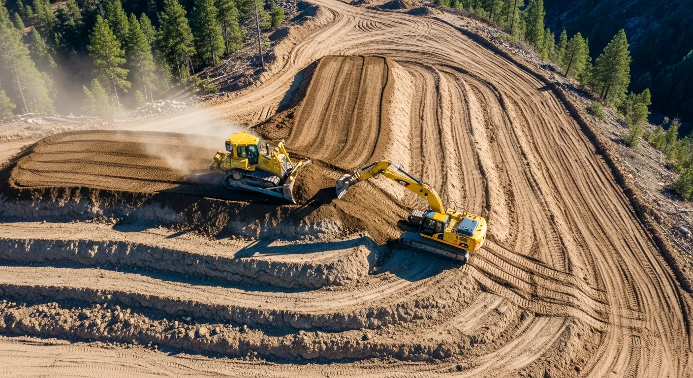
Dozers
Dozers are the most common platform for GPS machine control, and for good reason. A dozer spends its entire working life pushing material to a specified grade, making it the ideal candidate for automated blade control.
Sensor configuration: Two GPS receivers mount on masts at each end of the blade, or one on the cab and one on the blade. An IMU (inertial measurement unit) mounted on the blade frame provides slope and rotation data between GPS updates. The dual-receiver setup lets the system calculate blade slope directly, which is critical for cross-slope grading.
Automatic mode benefits: On a dozer, automatic blade control delivers the highest productivity gains because the operator can focus entirely on machine speed, direction, and material management while the system handles blade height and slope. Experienced operators in automatic mode consistently grade faster than the same operator working manually, even with indicate guidance.
Best applications: Rough grading, finish grading, building pad preparation, parking lot subgrade, and any large-area grading work. Dozers with GPS machine control excel at spreading and shaping material across open areas.
Productivity gain: Expect 30 to 50 percent improvement on rough grading and 40 to 60 percent improvement on finish grading compared to conventional staking methods.
Motor Graders
Motor graders are precision grading machines, and GPS machine control amplifies that precision significantly. The complex blade geometry of a grader (with its ability to rotate, shift, and articulate the moldboard) makes the control system more sophisticated than a dozer system.
Sensor configuration: GPS receivers mount on masts at each end of the moldboard. Additional sensors track blade rotation, side shift, and circle turn angle. Some systems also use a cross-slope sensor on the mainframe to separate machine lean from blade angle.
Automatic mode benefits: Automatic control on a grader can manage both blade height and cross-slope simultaneously. This is a significant advantage because maintaining consistent cross-slope manually requires constant attention from the operator, especially on long road sections.
Best applications: Road finish grading, shoulder grading, ditch grading, and any work requiring precise cross-slope control. Graders with machine control are particularly effective on long linear projects like roadways where consistent slope over distance is critical.
Productivity gain: Motor graders see 25 to 40 percent improvement in grading productivity, with the biggest gains on finish grading work where cross-slope accuracy is critical.
Excavators
Excavators present unique challenges for machine control because the bucket position must be calculated through a series of articulating joints (boom, stick, and bucket) rather than tracked directly by GPS.
Sensor configuration: GPS receivers mount on the cab roof (one or two, depending on the system). Angle sensors mount on the boom, stick, and bucket pins to track the position of each joint. The system uses the known dimensions of each component combined with the joint angles to calculate the bucket edge position in three-dimensional space.
Indicate mode dominance: Most excavator machine control operates in indicate mode rather than automatic because excavators perform too many different tasks (digging, placing, shaping, lifting) for full automatic control to work smoothly. The operator watches the display showing depth and slope and controls the machine manually. Some newer systems offer semi-automatic bucket control for trenching operations.
Best applications: Foundation excavation to precise depth, utility trenching, pond excavation, and any digging work where hitting a specific elevation matters. Excavator machine control eliminates the need for a grade checker in the trench, improving both productivity and safety.
Productivity gain: Excavator machine control typically delivers 20 to 35 percent improvement in trenching productivity and significantly reduces the chance of over-excavation, which saves on backfill material and compaction time.
Scrapers
Scrapers are high-production earthmoving machines, and GPS machine control helps them work smarter by showing operators exactly where to cut and where to fill.
Sensor configuration: GPS receivers mount on the bowl or yoke, with additional sensors tracking bowl height. The system is simpler than dozer or grader setups because scrapers are primarily concerned with cut depth and fill thickness rather than precise surface shaping.
Indicate mode is standard. Scrapers typically run indicate-only systems because the bowl control does not lend itself to automatic fine grading. The value of machine control on a scraper comes from real-time cut/fill mapping that shows operators exactly where material needs to come from and where it needs to go.
Best applications: Mass earthmoving on large sites, highway rough grading, and any project where scrapers are moving large volumes between cut and fill areas. The ability to see real-time volumes and progress on the display helps operators make better decisions about haul routes and loading sequences.
Productivity gain: Scrapers with GPS guidance see 15 to 25 percent improvement in overall earthmoving efficiency, primarily from better cut/fill balancing and reduced wasted haul cycles.
Compaction Rollers
GPS machine control on compaction equipment serves a different purpose than on grading machines. Instead of controlling the blade or bucket, the system maps where the roller has been and how many passes have been applied to each area.
Sensor configuration: A single GPS receiver on the cab tracks the roller’s position as it works. Accelerometers or compaction measurement sensors track vibratory frequency and amplitude. The system builds a real-time map showing coverage and pass counts.
Intelligent compaction benefits: The display shows the operator a color-coded map of pass counts. Areas that need more passes show in red. Areas that have reached the specified number show in green. This eliminates both under-compaction (which causes settlement) and over-compaction (which wastes fuel and time).
Best applications: Subgrade compaction, embankment compaction, and any fill placement where uniform compaction is specified. Intelligent compaction mapping can also generate documentation for quality assurance records, replacing traditional nuclear density testing on some projects.
Productivity gain: Compaction mapping typically reduces compaction time by 15 to 20 percent while improving uniformity, reducing the risk of settlement-related callbacks that can be extremely costly. Using Projul’s scheduling features to coordinate compaction crews with grading operations keeps your entire earthwork sequence on track.
RTK Base Station Setup: A Practical Field Guide
Setting up an RTK base station correctly is one of the most critical steps in any GPS machine control operation. A bad base setup means every machine on site is grading to the wrong elevation. This section provides a step-by-step walkthrough for field crews.
Choosing Between a Site Base Station and Network RTK
Before diving into base station setup, you need to decide which RTK correction method to use. Both have clear advantages and trade-offs.
Site base station (your own base): You set up a GPS receiver on a tripod over a known point on your project site. This receiver broadcasts corrections to all machines via radio. Advantages include full control over your correction source, no monthly subscription fees, and reliable radio coverage across the site. Disadvantages include setup time (15 to 30 minutes per day), the need for a known control point, and potential radio range limitations on large sites.
Network RTK (subscription service): Services like Trimble CenterPoint, Leica SmartNet, and Topcon TopNET Live operate networks of permanent reference stations across the country. Your machine receives corrections over cellular data connection. Advantages include zero setup time, no base station equipment to buy or maintain, and consistent accuracy across large areas. Disadvantages include monthly subscription fees ($200 to $500 per machine per month), dependence on cellular coverage, and occasional network outages.
When to choose a site base: If you work primarily in rural areas with limited cell coverage, run multiple machines on one site, or want to avoid recurring subscription costs, a site base station is the better choice. The upfront cost of a base station ($15,000 to $30,000) pays for itself in 3 to 12 months compared to network subscriptions for multiple machines.
When to choose network RTK: If you move frequently between small job sites, work in areas with good cellular coverage, or only run one or two machines, network RTK saves time and complexity. The convenience of arriving on site and being ready to grade immediately is significant.
Step-by-Step Base Station Setup
Follow this process every time you set up a site base station:
Step 1: Select the base station location. The ideal spot has a clear view of the sky down to 15 degrees above the horizon in all directions. Avoid locations near large buildings, heavy tree canopy, or power lines. The location should be centrally located relative to the working area and protected from construction traffic. Many crews pour a small concrete pad or drive a piece of rebar as a permanent base point that survives the entire project duration.
Step 2: Set up the tripod and receiver. Level the tripod carefully over the known point. Mount the GPS receiver on the tribrach or fixed-height pole. Measure and record the antenna height precisely. An error of even one centimeter in the antenna height measurement creates a one centimeter elevation error across the entire site.
Step 3: Configure the base station. Enter the known coordinates of the base point (easting, northing, and elevation in the project coordinate system). Set the broadcast format (RTCM or CMR/CMR+) to match your machine control system. Configure the radio frequency and power settings. Most base stations use 900 MHz spread spectrum or 450 MHz UHF radio.
Step 4: Verify the radio link. With the base broadcasting, drive a machine to the farthest point on the site and verify that the RTK correction link is solid. The machine should maintain a fixed RTK solution (typically shown as a green indicator on the display). If the link drops at the far edges, consider raising the base antenna, increasing radio power, or adding a radio repeater.
Step 5: Check the calibration. Drive the machine to at least two known control points and verify the displayed elevation matches the known elevation within your tolerance (typically plus or minus 0.03 feet or better). If the check fails, re-verify the base coordinates, antenna height, and site calibration file.
Step 6: Document the setup. Record the base point coordinates, antenna height, radio frequency, and calibration check results. This documentation helps troubleshoot if accuracy issues arise later in the day or project. With Projul’s project management tools, you can store this documentation alongside your project files so it is accessible to anyone on the team.
Base Station Troubleshooting Tips
RTK corrections dropping intermittently. The most common cause is radio interference from other equipment on the site or nearby. Try a different radio channel. Also check that the base station battery has adequate charge, as low voltage can reduce radio transmission power.
Elevation reads correctly at the base but drifts at distance. This indicates a potential issue with the site calibration or the coordinate system transformation. Re-run the site calibration using all available control points and check residuals. If residuals exceed 0.02 feet, investigate the control point quality.
Base station will not acquire satellites. Check for physical obstructions (new structures, cranes, or equipment parked nearby). Verify the antenna cable connections. In rare cases, a GPS antenna can fail internally and will need replacement.
Machines show different elevations from the same point. This usually indicates one machine has incorrect antenna height settings or a sensor calibration issue. Check each machine individually against a control point and re-calibrate the machine that disagrees.
ROI Calculation Framework for GPS Machine Control
While the earlier section covered general ROI concepts, this section provides a detailed framework you can use to build a business case with numbers specific to your operation. Plug in your own costs and utilization rates to see exactly what GPS machine control will save you.
Step 1: Calculate Your Current Baseline Costs
Before you can measure savings, you need to know what you are spending now. Track these costs across three to five representative projects:
Survey staking costs per project. Include initial staking, re-staking (typically one to three times per project as stakes get destroyed), and any additional survey checks during construction. Most commercial site grading projects spend $5,000 to $20,000 on construction staking alone.
Grade checker labor cost. Calculate the fully loaded cost (wages, benefits, insurance, truck, fuel) for each grade checker you employ. A full-time grade checker typically costs $55,000 to $80,000 per year including all burden. If you use grade checkers part-time across multiple crews, allocate the proportion that would be eliminated by machine control.
Over-excavation material costs. This is the hardest number to pin down but often the largest savings category. Measure actual quantities placed versus plan quantities on your last several projects. The difference is your over-excavation, which includes both the extra excavation cost and the extra material cost to fill back. Most contractors over-excavate by 8 to 15 percent when working from stakes.
Rework costs. Track any time your crews had to return to re-grade an area that was initially out of tolerance. Include equipment hours, operator labor, fuel, and any additional survey checks. Rework is often hidden in general project costs and can be surprisingly large when you start measuring it.
Fuel costs on grading operations. Isolate the fuel consumption specifically for your grading equipment. GPS machine control reduces total passes required, which directly reduces fuel burn.
Step 2: Estimate Your Machine Control Savings
Apply these typical percentage reductions to your baseline costs:
Staking cost reduction: 60 to 80 percent. You still need initial control points and periodic verification surveys, but the bulk of construction staking is eliminated. On a project that normally costs $12,000 in staking, expect to reduce that to $2,400 to $4,800.
Grade checker labor reduction: 50 to 100 percent. On dozer and grader operations with automatic control, the grade checker role is fully eliminated. On excavator operations running indicate mode, you may still want a grade checker for critical work, so the reduction is closer to 50 percent.
Over-excavation reduction: 25 to 50 percent. The tighter you grade to plan, the less material you waste. On a project with 5,000 cubic yards of over-excavation at $10 per yard (including excavation and replacement), a 35 percent reduction saves $17,500.
Rework reduction: 60 to 80 percent. Grading right the first time eliminates most rework. Some rework will always occur due to weather, design changes, or other factors, but the portion caused by grading errors drops dramatically.
Fuel reduction: 10 to 15 percent. Fewer passes and more efficient material movement reduce fuel consumption on grading operations.
Productivity increase: 25 to 50 percent. This is the multiplier effect. When your machines grade faster and more accurately, you can take on more work with the same fleet or complete existing work ahead of schedule. Tracking this productivity improvement is easier when you use Projul’s time tracking features to compare labor hours on GPS-equipped versus conventional grading operations.
Step 3: Calculate Total Annual Savings
Multiply your per-project savings by the number of grading projects you complete per year. Be conservative in your estimates. Use the low end of the savings ranges for your first-year projection, since there will be a learning curve as operators get comfortable with the system.
For example, a contractor completing 15 commercial site grading projects per year with an average staking cost of $10,000, one full-time grade checker, and 3,000 cubic yards of over-excavation per project:
Staking savings: 15 projects times $10,000 times 70% reduction = $105,000. Grade checker elimination: $65,000 per year. Over-excavation savings: 15 projects times 3,000 yards times $10/yard times 35% reduction = $157,500. Rework reduction: estimated $30,000 per year. Fuel savings: estimated $12,000 per year.
Total estimated first-year savings: $369,500.
Step 4: Compare Against Total System Cost
Add up all costs associated with the machine control investment:
Equipment purchase or lease. For a single dozer automatic system: $80,000 to $110,000 purchased, or $3,500 to $5,500 per month leased. Include the base station ($15,000 to $30,000) if applicable.
Network RTK subscription. If using network RTK instead of a site base: $300 to $500 per machine per month.
Training costs. Budget $3,000 to $5,000 for initial operator training, including trainer fees and lost productivity during the learning period.
Insurance. Add the GPS equipment to your inland marine policy. Annual premiums are typically 2 to 4 percent of equipment value.
Annual maintenance and repairs. Budget 3 to 5 percent of equipment value per year for cables, mounts, and occasional sensor replacement.
For the example above, equipping two dozers with automatic GPS at $95,000 each plus a $25,000 base station:
Total first-year investment: $215,000 purchase plus $8,000 training plus $8,600 insurance plus $9,500 maintenance = $241,100.
First-year net savings: $369,500 minus $241,100 = $128,400.
Payback period: approximately 7.8 months.
In year two and beyond, the annual costs drop to just insurance and maintenance (approximately $18,100), making the ongoing annual benefit approximately $351,400.
Step 5: Factor in Competitive Advantages
The ROI calculation above covers only direct, measurable savings. GPS machine control also delivers strategic advantages that are harder to quantify but equally important:
More competitive bids. When you can grade faster and more accurately, your costs are lower, which means you can bid lower while maintaining healthy margins. In a competitive market, this advantage wins projects.
Ability to take on complex projects. Some projects require machine control as a specification. Without it, you cannot even bid. Owning the technology opens doors to higher-margin specialty work.
Reduced project duration. Finishing grading faster means the entire project schedule compresses. General contractors notice when your crews consistently beat the schedule, and that reputation brings repeat business.
Better quality documentation. Many machine control systems generate as-built data automatically. This documentation reduces disputes about quantities and provides verification of work quality that clients and inspectors appreciate.
Improved safety. Eliminating grade checkers from active grading areas removes people from the path of heavy equipment. This reduces your risk exposure and can lower insurance premiums over time.
Getting Started: Your Action Plan
If you are considering GPS machine control for your operation, here is a practical path forward:
Step 1: Evaluate your current costs. Track your staking costs, material overruns, grade checker labor, and rework for three to five projects. You need baseline numbers to calculate ROI.
Step 2: Talk to your local equipment dealers. Get demos on your actual equipment. Most major dealers will set up a machine control system on your dozer or excavator for a field demo at no cost.
Step 3: Consider renting before buying. Monthly rentals let you prove the value on a real project before committing to a purchase. Many rental agreements apply a portion of rental payments toward a purchase.
Step 4: Start with one machine. Equip your primary grading dozer first. Learn the workflow, train your operators, and document the results before expanding to additional machines.
Step 5: Build your support network. Identify who will prepare your design files, who will troubleshoot field issues, and who will train new operators. This support infrastructure is as important as the technology itself.
GPS machine control is not just for the big contractors anymore. The technology has matured to the point where any operation doing regular grading or excavation work can benefit. The contractors who adopt it gain a real competitive advantage in bidding, production, and quality. The ones who wait will eventually have no choice, and they will wish they had started sooner.
Tools like Projul help you manage the projects where GPS machine control makes the biggest difference. From scheduling crews and tracking equipment to managing project budgets and communicating with clients, Projul keeps your entire operation organized so your GPS-equipped machines stay productive.
Frequently Asked Questions
What is GPS machine control in construction?
How accurate is GPS machine control for grading?
What is the difference between indicate and automatic machine control?
How much does GPS machine control equipment cost?
Do I need a base station for GPS machine control?
Can GPS machine control work on any heavy equipment?
How long does it take to train operators on GPS machine control?
What ROI can I expect from GPS machine control?
Related Articles

Concrete Tilt-Up Construction: A Contractor's Complete Field Guide
Tilt-up construction accounts for roughly 15 percent of all industrial and commercial buildings in North America. This...
Read More →
How to Implement Construction Software Without Losing Your Mind
Most construction software rollouts fail. Not because the software is bad, but because the rollout was rushed. Here are...
Read More →
How Selections Can Pay for Themselves in Three Easy Steps
Most contractors lose thousands each year on wrong material orders, slow client decisions, and missed upsell chances....
Read More →